On our quest to visit all the Wisconsin state parks, we took about a week from July 30 to August 3 (2023) to visit 5 of them and in the process made Ashland our port of call.
The five parks are these…and the names are linked to my descriptions of our hikes in each.
But I’m getting ahead of myself.
North to Ashland
To get to Ashland, we took I-39 / US 51 to the “top” of the state where the road ends in Hurley. We’d never been to Hurley. You’ve probably never been to Hurley. Most people have never been to Hurley…or it’s “twin city”, Ironwood, Michigan.
We were soon to have visited Hurley twice within a week.
The first visit included a stop at the rest area / info center near the intersection of US 51 and US 2. The building there doubles as the local DMV one day each week. We mostly stopped there because I’m also trying to visit as many Wisconsin Historical Markers as possible, and there’s one at this location about Iron Mining.
Just west of there on US 2 there’s another marker that for some time was missing according to HMDB. I almost didn’t stop for it, but we took a chance and found it had been replaced. I’m happy to say I got to update HMDB for this Gogebic Iron Range marker. (It’s kinda like a “collector thing”. If you understand, you understand.)
By the end of the day on that Sunday, we made it to the Crest Motel at the intersection of US 2 and Wisconsin 112 in western Ashland…just across the street from Kwik Trip #110. (Ashland has two more KTs.)
It’s on the shore of Lake Superior, as is much of Ashland.
 |
| Ashland shoreline |
Note, I don’t have many pictures specifically about our stay in Ashland. If you want to see what we saw, you’ll usually have to click the links to the markers or the state parks. All links should open in new tabs.
Further North to Madeline Island
The next day, Monday, we drove and sailed (ferried?) to Madeline Island to hike in Big Bay State Park.
On the way, we stopped at a Madeline Island marker just north of Washburn.
A major fail on this trip was neglecting to find the historical marker on Madeline Island itself. It will likely never be checked off my list. (Actually, I mean it will never be added to my list of visited markers at HMDB. Yeah, you can do that at the site. Geeky, huh?)
West to Pattison and Amnicon Falls
On Tuesday, we took in both Pattison State Park and Amnicon Falls State Park. We’d been to both of them before - almost exactly two years to the day, when we vacationed in Superior. But since I hadn’t dreamed of visiting all the state parks back then, I decided we had to visit them again to make them “count”.
On the way to Pattison, we stopped at a marker in Lake Nebagamon. I bet you’ve never been there either.
On the way back to Ashland, we found another marker in Poplar about Major Dick Bong. After that came another fail of missing a marker in Brule. To be fair, there were no brown highway signs alerting us to its location, so we’re not 100% sure the marker still exists. (It probably does.)
South to Copper Falls
On Wednesday we hiked in Copper Falls. I can see why this is one of the more popular state parks. I’d go back there again.
We spent one more night in Ashland. (We’d seen the three markers in town earlier in the week.)
East to Ironwood
Then we headed toward Governor Thompson State Park via Hurley.
We wanted to see this huge statue of Hiawatha…there. It turns out it’s actually in Ironwood, so we took a chance and crossed the border into the UP. (That’s the “You Pea” for those of you unfamiliar with the area who don’t know our shorthand for the Upper Peninsula of Michigan.)
Google docs thinks I should have spelled it “pee”. Makes sense, I guess.
At this one stop, we saw all of the following. It seems that, compared to Google maps images, Ironwood has been making quite a few additions to the area. They were adding the one sign in the distance while we were there.
 |
| Hiawatha (and Karen) |
 |
| Hiawatha plaque at his feet |
 |
| Miners Park signs at entrance to the area |
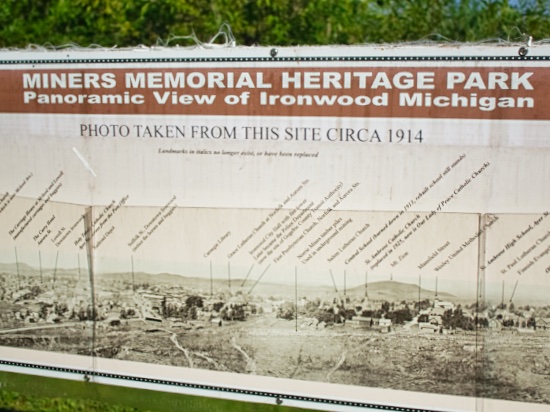 |
| Too wide to fit it all in decently |
 |
| Norrie Mine |
 |
| Iron Ore Industry |
There's a good reason many towns and other entities have "iron" in there name up there.
South (Again) to Governor Thompson
On our way to Popp’s Resort, which is just a few minutes southeast of Governor Thompson State Park, we stopped in Woodruff for two more markers - the World’s Largest Penny and the Dr. Kate Pelham Newcomb marker.
The next morning we hiked in the park and then headed for home. Along the way we found another marker in Rhinelander, home of the hodag. Here we also had our last fail. There is apparently a second marker in Hodag Park, but we couldn’t find it. (Again, no alert signs.) We even asked a local police officer if he knew where it was. He didn’t. Assuming it’s really there, it was several dozen feet behind us at the time of my chat with the officer.
We did get to see the largest hodag in town at the visitor center.
 |
| The fearsome hodag |
Just east of Crandon we found yet another marker. We stopped in Laona to see the world’s largest soup kettle.
 |
| World's Largest Soup Kettle |
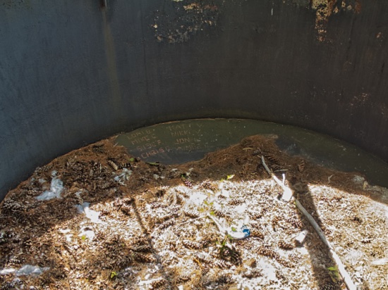 |
| Inside the kettle cuz inquiring minds... |
I had brought along a book I had borrowed from our son, Drew, and intended on returning it to him in Neenah. However, we learned that they were going to Bay Beach Amusement Park in Green Bay this day. No problem. Green Bay was also on our way home, so we surprised them by stopping at the park.
It was a nice way to end a nice vacation.
Only 3 parks and about 530 markers to go.
No comments:
Post a Comment